- Manuals
- Brands
- Haglof Manuals
- Measuring Instruments
- Vertex Laser Geo
- User manual
-
Contents
-
Table of Contents
-
Bookmarks
Quick Links
Vertex Laser Geo and Laser Geo User Guide ENGLISH
VERTEX LASER GEO/ LASER GEO
USER GUIDE 3.2
Vertex Laser Geo
LASER AND ULTRASOUND
©Haglöf Sweden
2021-02-02
User Guide – English
1
Laser Geo
LASER
Related Manuals for Haglof Vertex Laser Geo
Summary of Contents for Haglof Vertex Laser Geo
-
Page 1
Vertex Laser Geo and Laser Geo User Guide ENGLISH 2021-02-02 VERTEX LASER GEO/ LASER GEO USER GUIDE 3.2 Vertex Laser Geo Laser Geo LASER AND ULTRASOUND LASER User Guide – English ©Haglöf Sweden… -
Page 2: Table Of Contents
Vertex Laser Geo and Laser Geo User Guide ENGLISH 2021-02-02 HEIGHT DME – 2-POINT MEASURING WITH MANUAL CONTENTS DISTANCE …………… 19 OVERVIEW ……………. 4 MAP TRAIL …………..20 ® …………..4 AGLÖF WEDEN ……….21 ISTANCE WITH ASER VERTEX LASER GEO LASER GEO ……..
-
Page 3
Vertex Laser Geo and Laser Geo User Guide ENGLISH 2021-02-02 Turn on the GPS…………42 USE AS EXTERNAL GPS ………. 43 GPS fix ……………. 43 Store a Single Coordinate ……….. 44 ……….45 PS TO MEASURE AREA GPS DATA …………..45 EXAMPLES OF GOOGLE EARTH FILE, (KML FILE) ….. -
Page 4: Overview
3D measurements. Results are presented in an integrated heads-up display and on a large external graphic LCD display. The VERTEX LASER GEO model includes built-in, proven reliable ultrasonic distance technology, optimized for measurements in dense forest and for circular sample plot work.
-
Page 5
FORESTRY The VERTEX LASER GEO model is especially suitable for forestry measurement applications. The use of an ultrasonic transponder helps you to quickly and accurately determine if a tree is in or out a circular sample plot. The ultrasound method is superior compared to alternative methods, as it can be used in dense forests and areas with thick understory. -
Page 6: Instrument Overview
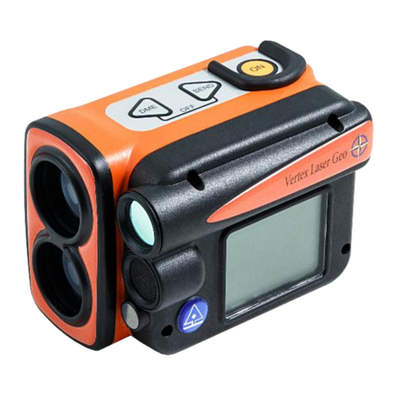
Vertex Laser Geo and Laser Geo User Guide ENGLISH 2021-02-02 INSTRUMENT OVERVIEW Buttons Laser optics Lens for Sight and Heads up display LCD display Ultrasound transreceiver (VERTEX LASER GEO) Ultrasound temperature sensor (VERTEX LASER GEO) Bluetooth transreceiver Rechargable Li-Ion battery GPS receiver 10.
-
Page 7: Transponder T3
2021-02-02 TRANSPONDER T3 A transponder T3 is (normally) included in the VERTEX LASER GEO instrument system. The transponder is equipped with an ultrasonic transmitter and a receiver that communicates with the measuring instrument. The transponder can be used both for aimed/direct measuring and for circular measuring, with the 360-degree adapter. To use the transponder to measure tree heights, remove it from the adapter/spreader and pin it to the tree stem at preset height.
-
Page 8: Functions And Use Of The Buttons
Vertex Laser Geo and Laser Geo User Guide ENGLISH 2021-02-02 FUNCTIONS AND USE OF THE BUTTONS BUTTONS The GEO instrument’s overlay contains three buttons: two arrow buttons and the ON button. One press at the ON button starts the GEO instrument. The ON button is used to select a menu command or a function; to confirm a selection or a value;…
-
Page 9: Sight
2000 measuring operations. Change of battery, if needed, can only be done by authorized service stations. MAIN SCREEN Press ON to start VERTEX LASER GEO / LASER GEO. The main menu is started. Name of instrument VL GEO (Vertex Laser Geo) or L GEO (Laser Geo) b.
-
Page 10: Menu Scheme
Use the DME- or SEND button to change current menu. Press ON to step to next position. To exit a menu, press the DME- and SEND buttons at the same time (Exit). Shortcut to DME function (ultrasound): Press DME button when the VERTEX LASER GEO is turned off.
-
Page 11: Settings
Vertex Laser Geo and Laser Geo User Guide ENGLISH 2021-02-02 SETTINGS In the SETTINGS menu, all settings are made to measure heights, distances and angles. 1. Press ON to activate the GEO instrument. 2. Select SETTINGS and press ON to confirm. Choose SETTINGS in the SET menu and press ON.
-
Page 12: Eye Hgt
20, 25, 30, 35, 40, 45, 50 (ft2/acre). Use the option ‘- -‘ to disable the BAF function. In leaning (inclining) terrain, the VERTEX LASER GEO can compensate for the inclination and calculate the diameter measure. In such cases, use the ANGLE function in the menu to measure the distance and angle from the tree to the reference point (see section ANGLE in this user’s…
-
Page 13: Compass
Vertex Laser Geo and Laser Geo User Guide ENGLISH 2021-02-02 COMPASS Select if the compass should be used in the height functions. Turning off the compass makes the height measurement go faster. The compass will always be used in functions that requires it or if both the GPS and Memory are activated.
-
Page 14: Azimuth
Vertex Laser Geo and Laser Geo User Guide ENGLISH 2021-02-02 http://www.magnetic-declination.com/ for latest info about magnetic declination. Deviations in some larger cities Anchorage 22° Orlando -5° San Francisco 15° Atlanta -4° Oslo -2° Seattle 19° Bombay -1° Paris -2° Shanghai -5°…
-
Page 15: Distance Measuring
For the LASER GEO instrument model, descriptions for the laser method are valid. There are two methods to measure distances in the VERTEX LASER GEO: laser or ultrasound. Which method to use for a field operation is determined by factors such as terrain composition and understory. Current weather conditions can also be of importance.
-
Page 16: Heights
Vertex Laser Geo and Laser Geo User Guide ENGLISH 2021-02-02 HEIGHTS The GEO instruments offer different methods for height measuring applications: HEIGHT 3P – 3-POINT MEASURING WITH LASER Distance and angle to optional part of target object measured with laser. The angle – inclination – is measured at the base and at the highest (top) part of the object.
-
Page 17: Height 1Pl — 1-Point Measuring With Laser
Vertex Laser Geo and Laser Geo User Guide ENGLISH 2021-02-02 HEIGHT 1PL – 1-POINT MEASURING WITH LASER Distance, azimuth and angle to an optional part of the object are measured with laser. To work with the Height 1-PL – (also: one-point or one-shot) method, the user must be positioned on the same horizontal level as the base of the target object.
-
Page 18: Height Dme — 2-Point Measuring With Ultrasound
Start the T3 transponder by holding the ultrasonic transceiver on the VERTEX LASER GEO instrument close to the center of the transponder and press the DME button on the VERTEX LASER GEO instrument. Wait for two short beeps from the transponder.
-
Page 19: Height Dme — 2-Point Measuring With Manual Distance
Vertex Laser Geo and Laser Geo User Guide ENGLISH 2021-02-02 HEIGHT DME – 2-POINT MEASURING WITH MANUAL DISTANCE Press ON to activate the instrument. Select HEIGHT DME and press ON to confirm your selection. Accept the distance value shown in the display (M.DIST) with a short press on the SEND button.
-
Page 20: Map Trail
Vertex Laser Geo and Laser Geo User Guide ENGLISH 2021-02-02 MAP TRAIL The MAP TRAIL function will enable you to collect target coordinates in a logical sequence by using either the laser or the ultrasound method, pitch and azimuth data. The MAP Trail function is useful when mapping different pathways, possible tracks or roads where GPS data is not accurate enough or when mapping for a cableway system in the forest to haul out logs.
-
Page 21: Distance With Dme Or Laser
Select DME and turn on the T3 transponder by holding the ultrasonic transceiver on the VERTEX LASER GEO instrument close to the center of the transponder and press the ON button MAP TRAIL STEP BY STEP Press ON to start the GEO instrument.
-
Page 22
Vertex Laser Geo and Laser Geo User Guide ENGLISH 2021-02-02 The GPS will start automatically (if GPS is enabled) to map your starting position when you store your first target. This is useful if you wish to import data to a GIS software later. The GPS data will be averaged until you press the ON button. -
Page 23: Trail Length
Vertex Laser Geo and Laser Geo User Guide ENGLISH 2021-02-02 13. Repeat points 9-12 to store next target. 14. When ready, select FINISH to finalize the trail. TRAIL LENGTH The total length (sum of all slope distances) of your trail is shown in the last screen.
-
Page 24: Map Target
Vertex Laser Geo and Laser Geo User Guide ENGLISH 2021-02-02 MAP TARGET The MAP TARGET function is useful for 3D mapping of different types of larger targets, such as buildings and piles. The same function can be used to calculate 2D areas, such as size of clear-cut areas, inside building areas and similar.
-
Page 25
Vertex Laser Geo and Laser Geo User Guide ENGLISH 2021-02-02 Start by selecting type of point to measure. Use DME and SEND buttons to shift type and press ON to start measure. All subsequent points will be of the same type until a new choice is made. Select between: LASER BASELINE –… -
Page 26: Dme Baseline
Vertex Laser Geo and Laser Geo User Guide ENGLISH 2021-02-02 12. Repeat point 4., 5., 6. and 7. to store next target. DME BASELINE DME BASLINE is only available for the VL GEO. Ultrasound can be used instead of laser to measure a point on the baseline of the object in case e.g.
-
Page 27: Example Google Earth File, Kml File
Vertex Laser Geo and Laser Geo User Guide ENGLISH 2021-02-02 EXAMPLE GOOGLE EARTH FILE, KML FILE The first example below shows target data from two different reference points. Each target position in the KML file is defined as “PXXX,Y” where ‘XXX’ is the Target ID and ‘Y’ is the measuring sequence. The KML file can be opened in Google Earth for a visual data quality check.
-
Page 28: Map Gps
Vertex Laser Geo and Laser Geo User Guide ENGLISH 2021-02-02 MAP GPS In MAP GPS a GPS coordinate is collected for each new target point instead of using reference points. For best precision, connect a sub meter GPS to the GEO instrument.
-
Page 29: Example Google Earth File, Kml File
Vertex Laser Geo and Laser Geo User Guide ENGLISH 2021-02-02 EXAMPLE GOOGLE EARTH FILE, KML FILE Each target position in the KML file is defined as “PXXX,Y” where ‘XXX’ is the Target ID and ‘Y’ is the measuring sequence. The KML file can be opened in Google Earth for a visual data quality check.
-
Page 30: Compass
Vertex Laser Geo and Laser Geo User Guide ENGLISH 2021-02-02 COMPASS COMPASS FUNCTION IN THE GEO INSTRUMENT Be aware that the expected azimuth error is around 1.5° RMSE. This is close to 3m/3yrd at 100m/100yrd. The error can be greater if magnetic objects are closer than 1-2m from the GEO instrument. The internal compass is sensitive to external factors, such as environmental changes, close-by objects such as mobile phones and handheld computers, and if the user is wearing metal-framed eye glasses.
-
Page 31: 3D Vector
Vertex Laser Geo and Laser Geo User Guide ENGLISH 2021-02-02 3D VECTOR The 3D vector function calculates the distance, angle and azimuth between two points. This implies that 3D data can be measured from a remote distance. This is very useful to measure objects such as canopy width or remote slope determination.
-
Page 32
Vertex Laser Geo and Laser Geo User Guide ENGLISH 2021-02-02 Press ON to start the GEO instrument. Select 3D VECTOR from the main menu and press the ON button. Point 1: Aim and press ON to measure with laser. Keep the instrument still until a signal is heard and a result is shown in the heads-up display. -
Page 33: Angle- Measuring Of Angles/Inclination
Make sure that the VERTEX LASER GEO instrument is turned off. Start the T3 transponder by holding the ultrasonic transceiver on the VERTEX LASER GEO instrument close to the center of the transponder and pressing DME. Await two (2) short beeps from the transponder.
-
Page 34: Line Clear
To re-measure, aim at the line again and press ON briefly. Repeat if needed. Accept the height value with the SEND button. Distance and height to the tree are measured with laser (VERTEX LASER GEO: or with ultrasound and the transponder T3): STEP 2: 3-POINT MEASURING WITH LASER…
-
Page 35: Step 2: 2-Point Measuring With Ultrasound In
Vertex Laser Geo and Laser Geo User Guide ENGLISH 2021-02-02 height (EYE HGT in the SETTINGS menu). If your object is covered by vegetation or branches, you can measure the distance and the angle to the top of the object instead. This point may however give uncertain results if the top has/is a broad/wide and diffuse crown.
-
Page 36: Min. Dist
Vertex Laser Geo and Laser Geo User Guide ENGLISH 2021-02-02 MIN. DIST. The MIN. DIST. function can be used to calculate the minimum distance from for example a tree branch or a tree top to a power line. The function is especially useful in situations when it is difficult to find a good position to make the measurement, because of native vegetation and the profile of the terrain.
-
Page 37: Step3 — Third Point On The Object
Vertex Laser Geo and Laser Geo User Guide ENGLISH 2021-02-02 STEP3 – THIRD POINT ON THE OBJECT When the red dot sight is turned on and you see the text P 3 and the text AIM AND PRESS ON TO FIRE LASER is shown in the display, aim at the part of the tree, or other object, that you like to know the minimum distance to and give a short press at ON to measure distance and angle to that point.
-
Page 38: Delta Hgt
Vertex Laser Geo and Laser Geo User Guide ENGLISH 2021-02-02 DELTA HGT DELTA HEIGHT FUNCTION The Delta Height function is used to estimate the height difference between a point on an imagined straight line between two (2) fixed positions and a third point, for example a power line, where the line sag is the closest to ground level.
-
Page 39
Vertex Laser Geo and Laser Geo User Guide ENGLISH 2021-02-02 7. Accept the distance and height to H1 and H2 with a short press at ON, DME or SEND. The red dot sight will light up again. Re- measure the value by giving another short press at ON or approve by moving forward with SEND. -
Page 40: Dme — Distance Measuring With Ultrasound Vertex Laser Geo
Start the T3 transponder by holding the ultrasonic transceiver on the VERTEX LASER GEO instrument close to the center of the transponder and press the DME button on the VERTEX LASER GEO. Wait for two short beeps from the transponder. The T3 transponder is now ON and will stay ON until turned off or after approx. 20 minutes of inactivity when it automatically turns off.
-
Page 41: Baf — Basal Area Function
If the VERTEX LASER GEO is in a pocket with a temperature of +15C and the outside temperature is at -5C, the measuring result will be 10.40m instead of the correct 10,00m. The temperature pending measuring fault at 10.0m is approx. 2cm/°C.
-
Page 42: Gps
Vertex Laser Geo and Laser Geo User Guide ENGLISH 2021-02-02 Your measuring data can be tagged with coordinates from the GEO instrument’s built-in GPS. It is also possible to use an external Bluetooth GPS receiver, such as the Geode or the Trimble R1, to obtain sub meter accuracy. When using GPS, your data can also be used in a GIS software such as Google Earth or similar.
-
Page 43: Use As External Gps
Vertex Laser Geo and Laser Geo User Guide ENGLISH 2021-02-02 USE AS EXTERNAL GPS The GEO instrument can also be used as an external GPS and send GPS data to another unit. Press ON to start the GEO instrument. Activate Bluetooth (select SETTINGS in the main menu and then BLUETOOTH) and let the unit, that is going to receive the GSP coordinates, connect to the GEO instrument.
-
Page 44: Store A Single Coordinate
Vertex Laser Geo and Laser Geo User Guide ENGLISH 2021-02-02 STORE A SINGLE COORDINATE Use the GPS menu to store a coordinate. Press ON to start the GEO instrument. Select SETTINGS from the main menu and menu GPS. Press the ON button.
-
Page 45: Use Gps To Measure Area
Vertex Laser Geo and Laser Geo User Guide ENGLISH 2021-02-02 USE GPS TO MEASURE AREA The Geo instrument has a feature for measuring an area with the built-in GPS or with an external Bluetooth GPS. The result can be seen directly in the GEO instrument after completion of the measurements.
-
Page 46: Examples Of Google Earth File, (Kml File)
Vertex Laser Geo and Laser Geo User Guide ENGLISH 2021-02-02 EXAMPLES OF GOOGLE EARTH FILE, (KML FILE) Below is an example of a KML file opened in Google Earth. CONTRAST – SETTINGS OF DISPLAY CONTRAST Press ON to activate the instrument.
-
Page 47: Enable Memory
Vertex Laser Geo and Laser Geo User Guide ENGLISH 2021-02-02 ENABLE MEMORY Enable the built-in memory to store results when pressing the SEND button. Note: When activating the memory function, the ability to send data via Bluetooth or IR is disabled Press ON to activate the instrument.
-
Page 48: Send Files Via Ble
Vertex Laser Geo and Laser Geo User Guide ENGLISH 2021-02-02 SEND FILES VIA BLE Stored files in the GEO instrument (CSV- and KML-files) can be sent via BLE (Bluetooth Low Energy) to an external unit, e.g. to the application Haglof Link for iOS and Android.
-
Page 49: Data Csv Fields
Vertex Laser Geo and Laser Geo User Guide ENGLISH 2021-02-02 DATA CSV FIELDS All fields are semicolon separated ‘;’ and decimal sign is ‘.’ . MARK ‘$’ (‘$’=Data, ‘#’=SETTINGS, ‘&’=reference point), STATUS (1=Valid, 0=Deleted), TYPE (“TRAIL”) PROD Product ID (1000), VER Firmware version (12), SNR serial nr (12324) ID Target Identity (00001), UNIT unit (‘M’=Metric, ‘F’=Feet), TRPH Transponder height (1.3), REFH Eye height (1.7), P.OFF Pivot…
-
Page 50: Bluetooth® — Communication
Vertex Laser Geo and Laser Geo User Guide ENGLISH 2021-02-02 BLUETOOTH® – COMMUNICATION The GEO instruments include built-in Bluetooth® for wireless transfer to PC, computer caliper or handheld computer. Some receiving units will ask for a pin-code to initiate connection. The default code in the instrument is 1234.
-
Page 51: Data Format
Vertex Laser Geo and Laser Geo User Guide ENGLISH 2021-02-02 DATA FORMAT IR — HAGLOF The IR Data packet contains a total of 40 signs. 1 0000<LF><CR> 2 0000<LF><CR> 3 0000<LF><CR> 4 0000<LF><CR> 5 +000<LF><CR> (At negative angle ‘+’is replaced with ‘-‘) <LF>=Linefeed (ASCII 10)
-
Page 52: Bluetooth Ble
Vertex Laser Geo and Laser Geo User Guide ENGLISH 2021-02-02 BLUETOOTH BLE The GEO instrument allows data transfer with Bluetooth Low Energy (BLE) devices, usually supported by Android and iOS. The transfer requires an App that supports the GATT service below. Data is sent by pressing the SEND button on the GEO instrument after a measurement.
-
Page 53: How To Calibrate The Compass
Vertex Laser Geo and Laser Geo User Guide ENGLISH 2021-02-02 HOW TO CALIBRATE THE COMPASS The Instrument is factory calibrated. There are no removable parts in the GEO instrument, and there is normally no need to recalibrate the compass. If the Instrument is exposed to a strong magnetic field, a recalibration is recommended, and this can be performed in CAL.COMPASS.
-
Page 54
Vertex Laser Geo and Laser Geo User Guide ENGLISH 2021-02-02 ©Haglöf Sweden… -
Page 55: Firmware Upgrade
Vertex Laser Geo and Laser Geo User Guide ENGLISH 2021-02-02 FIRMWARE UPGRADE The firmware in the Instrument can be user upgraded for new program releases or custom designed firmware with new functionality. Press ON to activate the GEO instrument. Connect the Instrument to a computer with the mini USB cable. The instrument automatically goes to USB mode.
-
Page 56: Technical Specification
Vertex Laser Geo and Laser Geo User Guide ENGLISH 2021-02-02 TECHNICAL SPECIFICATION Note that this technical specification includes descriptions for ultrasound valid for the VERTEX LASER GEO model only Physical Dimensions (L x W x H) 3.7×2.5×2.8”(93x63x72mm) Weight 8.6oz(243g) Housing and frame material…
-
Page 57: The Instrument Coordinate System
Vertex Laser Geo and Laser Geo User Guide ENGLISH 2021-02-02 Horizontal Angle (Compass) Units Angle Degrees 360⁰ Angle range 0.0⁰ to 359.9⁰ Resolution angle 0.1⁰ Accuracy 1.5⁰ RMSE Laser Min range 1.5ft/46cm Max range 2000ft/700m (depending on target) Accuracy 0.1ft /4 cm Resolution 0.1ft /0.1m (0.01m/0.1ft when using laser in DME mode)
-
Page 58
Vertex Laser Geo and Laser Geo User Guide ENGLISH 2021-02-02 GPS Performance Data Receiver type 33tracking/99 acquisition- channel GNSS receiver Update rate Sensitivity Tracking: -165 dBm Reacquisition: -160 dBm Cold starts: -147 dBm Time-To-First-Fix (All SV @ –130 dBm) Cold starts:… -
Page 59: Error Detection
Vertex Laser Geo and Laser Geo User Guide ENGLISH 2021-02-02 ERROR DETECTION LASER Symptom Check points Laser will not start/Display will not light up Charge battery Distance to target not reached Ensure that the laser beam is not blocked in the laser sensor or detector.
-
Page 60: Ultrasound
Vertex Laser Geo and Laser Geo User Guide ENGLISH 2021-02-02 ULTRASOUND Symptom Check points No distance presented in display Ensure that transponder is on/active. Poor battery. Repeated noise in surroundings (chain saws, highway traffic, crickets…) Use of wrong type of transponder…
-
Page 61: Compliance Statements/Déclaration De Conformité
COMPLIANCE STATEMENTS/DÉCLARATION DE CONFORMITÉ Product Origin: Sweden (EC) Declaration of Conformity: Haglöf Sweden AB hereby declare under our sole responsibility that the Vertex Laser Geo/Laser Geo instrument complies with the requirements of the following applicable European Directives: Electromagnetic Compatibility (EMC) Directive 2014/30/EU,…
-
Page 62: Warranty And Service Information
WARRANTY AND SERVICE INFORMATION The Vertex Laser GEO/Laser GEO is covered by a one-year limited warranty. Haglöf Sweden AB warrants that this product shall be free from defects in materials and workmanship, under normal intended use, for a period of 12 months after date of shipment.
-
Page 63: Software
Vertex Laser Geo and Laser Geo User Guide ENGLISH 2021-02-02 SOFTWARE © Copyrights of Haglöf Sweden AB Software belong to Haglöf Sweden AB. Unauthorized duplication is prohibited. Haglöf Sweden AB is registered trademark and VERTEX is a recognized trademark of Haglöf Sweden AB. Production is made in Sweden.
-
Page 64
Vertex Laser Geo and Laser Geo User Guide ENGLISH 2021-02-02 HAGLÖF SWEDEN AB KLOCKARGATAN 8 SE-882 30 LÅNGSELE, SWEDEN PH: +46 620 255 80 E-MAIL: INFO@HAGLOFSWEDEN.COM HAGLOF INC., P O BOX 2548, 100 SOLLEFTEA DRIVE MS 39110 MADISON, USA PH: +1 601 856 5119, FAX: +1 601 856 9075 E-MAIL: SALES@HAGLOFINC.COM…
Лазерно-ультразвуковой дальномер Vertex Laser Geo — объединение двух технологий измерения в одном приборе. Точные вычисления расстояния, высоты и уклона. Новая технология позволяет выполнять вам работу быстрее и эффективней! На открытой местности измеряйте расстояния с помощью лазера, для густого леса с плотным подлеском — пользуйтесь ультразвуком.
Vertex Laser Geo (Швеция) — прибор, позволяющий быстро и точно производить измерения на линиях электропередач, стройплощадках, автодорогах, лесном хозяйстве и т.д. С помощью прибора можно измерить высоту, ширину, объем, создать трехмерную карту объекта. Лазерный луч, используемый при измерении, безопасен для глаз.
Встроенный Bluetooth позволяет переносить данные (последнее значение) на карманный или стационарный компьютер для дальнейшей обработки.
Например, при работе в лесном хозяйстве можно вычислить высоту дерева, ширину кроны, объем пиломатериалов, общую площадь во время вырубки.
Способность Vertex Laser Geo измерять по горизонтали на 360 градусов, позволяет использовать инструмент для закладки реласкопических площадок. Вы быстро и точно определяете, находится ли дерево в радиусе или нет. С помощью встроенной функции BAF вы можете оказаться у дерева и определить его минимальный диаметр для включения в точечную пробу. Функция BAF позволяет точно отбирать точечную пробу в густых зарослях, что обычно невозможно сделать с помощью стандартной призмы.

Laser Geo поддерживает совместную работу с вилками Haglof MD II и Haglof DP II
Наличие Bluetooth позволяет передавать информацию о измеренных высотах на мерные вилки Haglof буквально в одно касание, таким образом, все данные (диаметр дерева, порода, высота) собирается в одном инструменте, что значительно упрощает дальнейшую обработку данных.
При работе на линиях электропередач, с помощью LASER GEO можно измерить следующие параметры:
- Расстояние между опорами

- Ширину просеки
- Высоту опоры
- Провис проводов линий электропередач
- Горизонтальные и вертикальные углы
- Опасность повреждения линии электропередачи падающими деревьями
- Расстояние от объекта до провода линии электропередач

Функция сканирования:
Если удерживать кнопку POWER в нажатом состоянии — прибор переходит в режим сканирования. Эта функция полезна при измерении на тонких объектах (например, проводов линий электропередач)
Встроенный Bluetooth позволяет переносить данные (последнее значение) на карманный или стационарный компьютер для дальнейшей обработки.
Поставляется в следующих комплектациях:

1) Vertex Laser Geo/360: Vertex Laser Geo, ультразвуковой транспондер, штатив и адаптер для круговых измерений.

2) Vertex Laser Geo/60: Vertex Laser Geo и ультразвуковой транспондер
Подбор параметров
Подбор параметров
Цвет
Камуфляж
Синий меланж
Синий меланж, Лиловый меланж
Черный
оливковый
хаки
Диапазон измерений, мм
|
0-400 |
|
0-500 |
|
0-520 |
|
0-600 |
|
0-640 |
|
0-650 |
|
0-800 |
|
0-950 |
|
0-1000 |
|
0-1020 |
|
0-1200 |
|
0-1270 |
Цвет
белый
желтый
зеленый
красный
синий
черный
Цвет
белый
желтый
красно-белая
синий
Цвет
зеленый
красный
малиновый
оранжевый
синий
Тип рулетки
для измерения диаметра
лесная
с закрытым корпусом
с открытым корпусом
Материал ленты
лента ПВХ
металл
сталь
стальная с нейлоновым покрытием
фиберглас
Размер (ЦФ)
|
52 |
|
52-54 |
|
56-58 |
|
60-62 |
|
64 |
|
64-66 |
Материал
RipStop 18 с покрытием ПУ, подкладка из сетки, нейлон
Костюм из материала ТС – 120 – (35х/б — 65 п/э)
Микрофлис (100% полиэстер) состоящий из тончайших 100% полиэстеровых волокон.
ПВХ, Винитол
винитол, ПВХ
палаточное полотно (100 хлопок)
Количество в коробке, шт.
Тип
круглый
плоский
трехгранный
Размеры, см
5,4 x 10,3 x 3,3
5.4 x 10.3 x 3.3
6,1 x 16,0 x 3,6
6,2 x 16,3 x 3,5
6,77 x 17,40 x 4,23
6.1 x 16.0 x 3.6
6.6 x 15.2 x 3.0
8,8 x 14,8 x 2,4
8.76 x 18.30 x 3.27
17,3 x 9,9 x 1,9
17.3 x 9.9 x 1.9
19.9 x 12.2 x 2.4
Размеры дисплея
2.6″ (6.6 cm)
2.6″ (6.6 см)
2.6″ (6.6 cm)
3″ (7,6 см)
3.0″ (7.6 см)
3.6 x 4.3 см; диагональ 2.2″ (5.6 см)
5″ (12.7 см)
5.5 дюйма
6.1″
6.95″ (17.7 см)
7.0″
11,1 х 6,3 см; диагональ 5,0″ (12,7 см)
Разрешение дисплея
128 x 160
128 х 240 пикселей
160 x 240
240 x 320
240 x 400
480 x 800 пикселей
480х272 пикселя
1024 x 600
1280 x 720
1280 x 720 px
Тип дисплея
WVGA трансфлективный, сенсорный экран
ЖК-дисплей (4 уровня серого)
Трансфлективный, 65K цветной TFT
Трансфлективный, 65K цветной TFT
монохромный
цветной, TFT
Тип батареи
2 AA батарейки (не включено); NiMH или Литий ионные
2 AA батарейки (продаются отдельно); NiMH или Литий ионные (рекомендуется)
Аккумуляторная литий-ионная
Аккумуляторная литий-ионная (в комплекте) или 3 батареи AA (не в комплекте); рекомендуются литиевые
Батарейки / аккумуляторы
Срок работы батареи, час
1
3
16
16 часов в режиме GPS; до 170 часов в режиме трекера (экспедиция)
25
До 2 часов
До 18 часов
до 6
до 19
до 20
до 180
Водонепроницаемость
Да
Да (IPX7)
Защищенность по военному стандарту MIL STD 810G (температура, вода, тряска)
Нет
Интерфейс
ANT +™, Bluetooth®4.0, USB и NMEA 0183 совместимый
Bluetooth / ANT+
USB
USB и NMEA 0183 совместимый
Возможность установки карт
Тип
адгезионная смазка для цепи
редукторное
Использование карт памяти
Тип карт памяти
microSD (microSDHC)
microSD™
microSD™
microSD™ (не входит в комплект)
microSD™ карта (не включено)
Карта microSD ™ (не входит в комплект)
Маршруты
50
200
250 с количеством точек до 250 в маршруте
Треки
10,000 точек, 100 сохраненных треков
10,000 точек, 200 сохраненных треков
10,000 точек, 200 сохраненных треков
20,000 точек, 250 сохраненных треков
20,000 точек, 250 сохраненных треков; 300 сохраненных активностей FIT
Электронный компас
Да
Да ( с компенсацией наклона, 3-х осевой)
Да ( с компенсацией наклона, 3-х осевой)
Нет
да
Вес с батареями , г
|
141,7 |
|
141.7 |
|
175 |
|
177,2 |
|
203 |
|
217 |
Длина, мм
|
100 |
|
150 |
|
200 |
|
250 |
|
300 |
|
350 |
|
400 |
|
450 |
|
500 |
|
600 |
|
700 |
|
800 |
|
930 |
|
1000 |
|
1300 |
Производитель
Bleispitz
Champion
DDE
Fisco
Fiskars
GP
Gardena
Garmin
Gross
Haglof
Hanakawa
Holzfforma
Hultafors
Husqvarna
Krok
Moscompass
Nestle
Nikon
Oregon
Petzl
Pfanner
ROER
Sarma
Senshin
Sisuputki
Soppec
Stanger
Stayer
Stihl
Sturman
Suunto
Taimi
Tramontina
Vento
Weiss
Австрия
Беларусь
Боевой трикотаж
ВОЛАТ
Вертикаль
Германия
Канада
Китай
Маяк
Назия
Орион-Альп
Рокс Пласт
Россия
СВТ
Финляндия
Швеция

Высотомер Vertex Laser Geo 360°, Haglof
Цена
395 950 руб.
Последняя цена
-
Описание
-
Характеристики
Высотомер Vertex Laser Geo 360° для лесников, землемеров, инженеров, ландшафтных архитекторов, строителей. Измерение высоты, кроны и положение дерева, картографирование площади, маршрутов, уклона местности, груд опилок и породы, выполнение замеров на линиях электропередач, провис провода и кабеля ЛЭП.
Преимущества лазерного ультразвукового дальномера Vertex Laser Geo:
• Измерения с помощью высокоточного лазера и ультразвука.
• Измерение кроны и высоты деревьев. Красная точка прицела для легкой фиксации верхушек деревьев.
• Измерение площади.
• Встроенный компас для точных трехмерных измерений.
• Подходит для работ в лесу, использования в лесозаготовительной и деревообрабатывающей промышленности, коммунальной сфере.
При работе на линиях электропередач (ЛЭП) высотомер Vertex Laser Geo позволяет измерить следующие параметры:
• Расстояние между опорами
• Ширину просеки.
• Высоту опоры.
• Провис проводов линий электропередач.
• Горизонтальные и вертикальные углы.
• Опасность повреждения линии электропередачи падающими деревьями.
• Расстояние от объекта до провода линии электропередач.
Инвентаризация штабелей бревен и запасов.
С помощью приложения 3D Pile возможны измерения объема штабеля бревен или объема куч различных материалов (щепа, песок, гравий и т.д.).
Комплектация: высотомер Vertex Laser Geo, транспондер Т3, штатив, адаптер 360°.
- Габариты, мм:
- 93х63х72
- Дистанция, м
- 46 см — 700 м
- Рабочая температура, °С
- -20 — +45
- Напряжение питания, В
- 3,7
- Типоразмер батареи
- Заряжаемая, литий-ионная
- Вес с батареями, г
- 243
- Корпус
- армированный пластик
- Страна изготовления
- Швеция
- Производитель
- Haglof
Сортировать по:
Вид:
Отображать по:
товаров
Артикул: 15-105-2001
Высотомер Vertex 5 — это предпочтительный инструмент многих лесников для точного измерения высоты, угла и расстояния в лесу. Ультразвуковой высотомер можно использовать в густой растительности и подлеске.
• Измеряйте расстояние до 30 метров с разрешением 0,01 м даже в густой растительности и с точностью +-1% или лучше при калибровке.
• Измеряйте высоту до 999 метров с разрешением 0,1 м.
• Измеряйте углы в градусах 360°, градусах 400° или процентах % с разрешением 0,1°.
• 5000 наборов данных могут быть сохранены во встроенной памяти и сохранены в виде CSV-файла.
• Bluetooth ® 4.0 (BLE) можно использовать для беспроводной передачи данных на устройства с Android, iOS или Windows.
• Функция базальной области (BAF) для определения минимального диаметра DBH, что дерево больше всего имеет, на точке выборки, которая должна быть подсчитана.
• Многоязычность, выберите предпочтительный язык.
Комплектация: прибор Vertex 5, транспондер Т3 (отражатель), адаптер, штатив.
200 308 руб.
Последняя цена
Артикул: 15-105-2002
Высотомер Vertex 5 — это предпочтительный инструмент многих лесников для точного измерения высоты, угла и расстояния в лесу. Ультразвуковой высотомер можно использовать в густой растительности и подлеске.
• Измеряйте расстояние до 30 метров с разрешением 0,01 м даже в густой растительности и с точностью +-1% или лучше при калибровке.
• Измеряйте высоту до 999 метров с разрешением 0,1 м.
• Измеряйте углы в градусах 360°, градусах 400° или процентах % с разрешением 0,1°.
• 5000 наборов данных могут быть сохранены во встроенной памяти и сохранены в виде CSV-файла.
• Bluetooth ® 4.0 (BLE) можно использовать для беспроводной передачи данных на устройства с Android, iOS или Windows.
• Функция базальной области (BAF) для определения минимального диаметра DBH, что дерево больше всего имеет, на точке выборки, которая должна быть подсчитана.
• Многоязычность, выберите предпочтительный язык.
Кмоплектация: прибор Vertex 5, транспондер Т3 (отражатель).
205 233 руб.
Последняя цена
Артикул: 15-103-1111
Высотомер Laser Geo для лесников, землемеров, инженеров, ландшафтных архитекторов, строителей.
Измерение высоты, кроны и положение дерева, картографирование площади, маршрутов, уклона местности, груд опилок и породы, выполнение замеров на линиях электропередач, провис провода и кабеля ЛЭП.
Преимущества лазерного дальномера Laser Geo:
• Измерения с помощью высокоточного лазера.
• Измерение кроны и высоты деревьев. Красная точка прицела для легкой фиксации верхушек деревьев.
• Измерение площади.
• Встроенный компас для точных трехмерных измерений.
• Подходит для работ в лесу, использования в лесозаготовительной и деревообрабатывающей промышленности, коммунальной сфере.
При работе на линиях электропередач (ЛЭП) высотомер Laser Geo позволяет измерить следующие параметры:
• Расстояние между опорами
• Ширину просеки.
• Высоту опоры.
• Провис проводов линий электропередач.
• Горизонтальные и вертикальные углы.
• Опасность повреждения линии электропередачи падающими деревьями.
• Расстояние от объекта до провода линии электропередач.
Инвентаризация штабелей бревен и запасов.
С помощью приложения 3D Pile возможны измерения объема штабеля бревен или объема куч различных материалов (щепа, песок, гравий и т.д.).
При работе в густых зарослях используется модель Vertex Laser Geo 60° / Vertex Laser Geo 360° лазерный дальномер с функцией ультразвукового измерения.
Видео. Инвентаризация и измерение штабеля Видео. Измерение и расчет объема куч
249 876 руб.
Последняя цена
Артикул: 15-103-1102
Высотомер Vertex Laser GEO 60° для лесников, инженеров, ландшафтных архитекторов, строителей.
Измерение высоты, кроны и положение дерева, картографирование площади, маршрутов, уклона местности, груд опилок и породы, выполнение замеров на линиях электропередач, провис провода и кабеля ЛЭП.
Преимущества лазерного ультразвукового дальномера Vertex Laser Geo:
• Измерения с помощью высокоточного лазера и ультразвука.
• Измерение кроны и высоты деревьев. Красная точка прицела для легкой фиксации верхушек деревьев.
• Измерение площади.
• Встроенный компас для точных трехмерных измерений.
• Подходит для работ в лесу, использования в лесозаготовительной и деревообрабатывающей промышленности, коммунальной сфере.
При работе на линиях электропередач (ЛЭП) высотомер Vertex Laser Geo позволяет измерить следующие параметры:
• Расстояние между опорами
• Ширину просеки.
• Высоту опоры.
• Провис проводов линий электропередач.
• Горизонтальные и вертикальные углы.
• Опасность повреждения линии электропередачи падающими деревьями.
• Расстояние от объекта до провода линии электропередач.
Инвентаризация штабелей бревен и запасов.
С помощью приложения 3D Pile возможны измерения объема штабеля бревен или объема куч различных материалов (щепа, песок, гравий и т.д.).
Комплектация: высотомер Vertex Laser Geo, транспондер Т3.
374 202 руб.
Последняя цена
Vertex Laser Geo and Laser Geo User Guide ENGLISH
2021-02-02
GPS AND MAPPING
The built in GPS-receiver and a 5-position numeric ID-attribute allow you to tag important data with coordinates with a simple
key press. Your data is stored on a built in SSD drive and are immediately available to you when connecting the GEO standard
USB 2.0 interface to any PC or Apple computer. No software installation or drivers are needed, and your field data can be
opened straight in your favorite GIS- or spreadsheet application without any special converting software.
Complex operations such as area measurement, 3D mapping of targets and trail mapping have integrated functions in the GEO
instruments. These functions are available without any external tools. The 3D Vector function allows you to measure horizontal
targets such as canopy width or height of piles or heaps.
FORESTRY
The VERTEX LASER GEO model is especially suitable for forestry measurement applications. The use of an ultrasonic transponder
helps you to quickly and accurately determine if a tree is in or out a circular sample plot. The ultrasound method is superior
compared to alternative methods, as it can be used in dense forests and areas with thick understory.
HEIGHTS
Standard height measuring functions with laser (VERTEX LASER GEO: also ultrasound) such as 3-point, 2-point or 1 point
measuring are available in the easy-to-follow menu system. The non-magnification red dot sight helps you to easier identify
individual targets such as tree tops in the forest.
UPGRADES AND CUSTOMIZATIONS
Firmware in the GEO instruments can be upgraded by the user. New features are available for you to purchase and implement
as soon as they are ready & released. Alternative firmware’s for user specified utilization standard applications can be offered at
development and license costs.
COMMUNICATION AND ENERGY
The built-in Bluetooth V4, Low Energy transceiver, enables long range wireless data transfer to your favorite handheld device.
The GEO instruments have built-in, long-lasting Li-Ion battery that are charged with mini USB interface.
©Haglöf Sweden
5
High-precision laser rangefinder with built-in GPS and compass
Rangefinder — Hypsometer — Bluetooth — Compass — GPS — Usb — SSD disk
Vertex Laser Geo
New models with EXTREME functionality- programmable with built in GPS & Compass
Rangefinder — Hypsometer — Bluetooth — Compass — GPS — Usb — SSD disk
Haglöf Sweden introduces the laser rangefinder models with outstanding capacities for your most accurate and efficient field measurement operations.
Vertex Laser model with outstanding capacities for your most accurate and efficient field measurement operations

Features
The VERTEX LASER GEO with unique capabilities will allow you to measure, map, process and store forest and field data in a way you didn’t think was possible! Long range measurement with high precision laser and integrated tilt- and compass sensors for accurate 3D measurements. Results are presented in an integrated heads-up display and external, graphic display.

3-point, 2-point or 1-point or direct measuring – choose preferred method to work with in the easy-to-follow menu system. A nonmagnification dot sight helps you to identify individual targets such as tree tops and power lines.
With Vertex Laser Geo, you can choose to use Ultrasound to measure distances in dense vegetation with a lot of undergrowth.

Use built in GPS to walk and log an area.
Or stand in the middle of the area and use the built in GPS, Compass, Laser and measure the points on the border of the area.
See results directly in Google Earth or other similar geographic applications.

![]()
Hazard trees
Line Clearance function.
- Measure on the wire
- Measure the tree height
- The unit calculates if the tree will fall on the wire or not.
- The unit calculates and present how much the tree will hit the the line or how much will go under the li
GPS and Mapping

The built in GPS-receiver and a 5-position numeric ID-attribute allow you to tag important data with coordinates with a simple key press.
Your data is stored on a built in SSD drive and immediately available for further processing when connecting a standard USB 2.0 interface to any PC or Apple computer.
No installation routines, converting software or special drivers are needed. Your field data can be opened straight in your favorite GIS- or spreadsheet application.
Complex operations such as area measurement, 3D mapping of targets and Trail mapping have integrated functions that also are available to you without any external tools. The 3D Vector function allows you to measure horizontal targets such as
canopy width.

Sample points
When using a prism or similar, there is the BAF function “Basale Area Function” to control the minimum (DBH) that the tree must have to be counted at sample points.
BAF factors: 0.5, 1 to 9 (m2/ha) or 5, 10, 15..to 50 (ft2/acre)
Vertex Laser Geo can be used in dense vegetation and undergrowth when usig ultrasound

The 3D Vector function allows you to measure remote targets such horizontal distances and angles between two points far ahead in the terrain such as canopy width or width of a river.

Your content goes here. Edit or remove this text inline or in the module Content settings. You can also style every aspect of this content in the module Design settings and even apply custom CSS to this text in the module Advanced settings.

Your content goes here. Edit or remove this text inline or in the module Content settings. You can also style every aspect of this content in the module Design settings and even apply custom CSS to this text in the module Advanced settings.
- Features
- Specification
- Media
- GPS
- Compass
- Distance up to 700 meters
- Data storage
- USB for file transfer and charging
- CSV and Google Earth KML files
- Software upgradable
- Bluetooth and IR
- Heads up display and Graphic main display
- Built in Lion battery
- IP67
| Size | 93x63x72mm/3.7×2.5×2.8” |
| Weight | 243 g/8.6oz. |
| Battery and consumption |
|
| Communication | IR, Bluetooth® BLE 4.0 class 2, Spp (serial profile), pin-code 1234, USB 2.0/SSD Disk. |
| Temperature | -20° to +45° C/ -4°F-113°F. |
| ULTRASOUND (Vertex Laser Geo) |
Only Vertex Laser Geo. |
| Height | 0-999 m/ft. Resolution height: 0.1 m/ft. |
| Angle | -90° – 90°. Unit: Degrees 360⁰, Grads 400⁰ and %. Resolution: 0.1⁰. Accuracy: 0.1⁰ typical. |
| LASER |
|
| Areal |
|
| GPS |
33-channel high sensitivity receiver. Supports GPS, Glonass, Galileo, QZSS. Built-in real tme correction w SBAS (EGNOS, WAAS, MSAS, GAGAN) Accuracy down to 2.5m/8.19ft in open terrain. Satellite position prediction for up to 3 days. Host Based multi-global navigation satellite system GPS(USA)/GLONASS(Russia)/Galileo(EU)/QZSS(JAPAN) SBAS Satellite-based augmentation systems: WAAS(US) EGNOS(EU) GAGAN (India) MSAS(Japan). Built-in self-generated orbit prediction (Faster TTFF up to 3 days), built-in jamming removing. Accuracy: Automatic position 2.5m CEP (circular error probable) (50% 24 hr static, -130dBm. Speed 0.1m/s (50%@30m/s. |
| Compass | Azimuth compass 0-360˚, resolution 0,1˚, accuracy <1.5 RSME˚. |
| Classification | MIL-STD-810E. Housing frame material glass filled poly carbonate, IP67, NEMA6, Laser class 1, 7mm (FDA, CFR21) Class 1m (IEC 60825-1:2001). |
| Sight | Yellow dot aim 1 x magnification. |
| Display | External Graphic LCD 100x60pixles. Internal Heads-up display. |
| Dataformat | Nmea or Ascii. IR, Bluetooth. |
| File Format | CSV and KML (Google Earth). |
| Memory | 2000 datasets, non-volatile. |
| Other information | Adapter and monopod staff, 4-parts (33-140cm) Aluminum transport/storing case. See user manual for more details. |
:
3D Pile
Expand the possibilities of your Laser Geo or Vertex Laser Geo with the 3D Pile application.
Specially adapted for Log and Stockpile inventoryanced settings.
Use the 3D pile application in your Laser Geo or Vertex Laser Geo to measure the volume of any irregular stockpile or log piles.
This complete system allows one person to perform the entire job without other instruments

- Inventory and volume estimation of log piles
- Inventory and volume estimation of irregular piles of different materials.
- One person can perform the entire process
- Obtain field data with high accuracy and precision
- Store data directly in the instrument
- Avoid walking and climbing in hazardous areas

The Log pile can be divided into several sections during measurement. The sum of the sections is then the total length of the pile. Measure and record pile width, range and wood volume factor for each section. The volume is calculated by section number, number of heights, calculated average height, and volume for each section. The result includes the calculated average width of each section, the calculated average height of all measuring points, and the default wood volume factor for each section.

The 3D PILE software is useful for measuring different types of piles and rollers. Measure the pile from different sides to create a three-dimensional image of the object. The instrument saves heights and coordinates for all measurement points. Data is stored in (csv) and (kml) formats and can be opened directly in Google Earth! The instrument can also be used to calculate 2D areas (area), such as clearcuts, industrial sites or the inside of a building.